Roads, Signs and Murder
This weekend is going to see hot weather again. I despair. It feels very much like the end days to me. It's October and I'm wearing a T-shirt. Tomorrow it might reach 26 degrees and I'll be overdressed.
I digress. I've thrown myself north eastward and I'll apologise now for the roadiness of the walk. I won't apologise for the pub options. As it stands, if you're experiencing wet weather, this might prove beneficial but, on the flipside, the parts of it being bridleway might prove quite muddy.
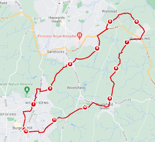
The first section of the walk takes you from the station up Mill Road and St Wilfred's Road to Wivelsfield Station. You could start here also. Briefly pet the horse, on through the caravan park and very briefly to Bedelands.
It's regretful to miss out on a wander in Bedelands but we must be on our way. Exit eastward, over the level crossing and onto Valebridge Road. Cross over and backtrack south into World's End, with views towards Burgess Hill. Take the next right of way on the left.
You're going to take the route known as Theobalds Road. What I'd like you to imagine is that you are an intinerant, on your way to ply your goods in Haywards Heath. The odd horse and cart you will meet on this very ancient route between the two settlements. In truth, this is the beginning of quite a well-worn byway, helpfully, historically and contextually interpretted by some signs (8 of them). In the spring, the woodland either side is full of bluebells and on one occasion, I spotted an albino squirrel. As I scrabbled for my camera it scampered off. I had to hold the white vision amongst the blue in my mind's eye instead. Continue on the bridleway, rather than the footpath, all the way until you meet a bit of water, the smell of Himalayan Balsam and houses. The residents in these parts are, rightly, very precious about this route to Haywards Heath being preserved for use by walkers and horses and as you go, you are aware of the proximity of the two towns.
I had walked back via this route at the time the houses here were being built and had been unable to take the route marked on the map because of the diggers. Curiously the footpath is still marked straight through the houses but it seems sensible to follow Blanford Avenue round to the path that takes you through to the Fox and Hounds on Fox Hill.
Too early to stop, continue on Hurstwood Lane until you reach Colwell Lane. Follow this all the way to the A272 Lewes Road and turn right until you get to Snowdrop Lane. This was once Lyoth Lane and it seems Lyoth Common is long gone. Views over the hedge to the north. Still too early for the Snowdrop Inn, exit onto the Scaynes Hill Road. Go left and then take the footpath through the stud. You'll follow a narrow hedgy hollow until you emerge in a horse field. Cross this to join the Sussex Ouse Valley Way going south. In truth I got a bit disorientated and reached a gate on the edge of the wood. Whilst I figured out where I'd gone wrong, four horsey heads were suddenly next to me. Luckily I figured out the path was to the left and a proper entrance to the field. I stopped at a bench in a small clearing. You'll end up following a line of telegraph poles. Costells Wood is Woodland Trust and looks like it could be explored.
Exit onto Scaynes Hill Common - an actual small common. and head south on Church Road to The Farmers. Head to the front door but, alas, follow the footpath to the right until it turns into another road and onto Ham Lane. A mildly aggressive font tells that you you're on the way to the farm.
Lovely views away to the Downs open out to the south. Here, what the Sussex Border Path lacks in pathiness it makes up for with ambience. At Hooters Garage, follow the finger posts rather than the map all the way to the footpath between Wilderness and Strood Wood. Leave the Border Path and head up to follow the edge of a sheep field. Leave this at the corner and cross the field beyond. Pay attention to your map to exit at Strood Farm. I doubtfully hopped a fence onto the drive before realising I'd been right all along. Keep going to North Common Road.
With any luck you'll be perfectly timed for lunch at The Cock Inn. Post lunch I dragged my legs along more road. Continue on Green Road until the corner of the recreation ground. Take Eastern Road and after Lockstrood Farm, keep to the centre of the trees. The other side was once the Royal Oak pub, now demolished and the site of a terrible murder by Jacob Harris AKA Yacob Hirsch. Finally smoked out of a chimney he was hiding in, his body was hung here after his execution. 'Jacob's Post' is apparently now near Bankside Farm. I missed that detail and hung around the junction hoping to see it before reminding myself I hadn't ever recalled seeing it.
Follow the path by the road and then cross Jane's Lane to join the bridleway, turn left then right, cross Kings Way and then the level crossing. After this the path forks. The right path will take you onto Ferndale Road. You can make your way back to the roundabout and the Station. Taking the other footpath, you could extend your walk but I had shopping to do for tea.


Comments
Post a Comment