Over the Hills and a Long Way Off
As Storm Ciarán blew onwards, it left Friday clear to make good on my promise to work my legs up a few hills. As hills go, Burgess Hill isn't going to present you with much of a challenge. The South Downs, on the other hand, is an obvious destination but I dithered a little in choosing my route to Wolstonbury Hill. It matters little but I'm never keen on duplicating a recent route. I knew there would be a good deal of water on the ground but the shoes are holding up well.
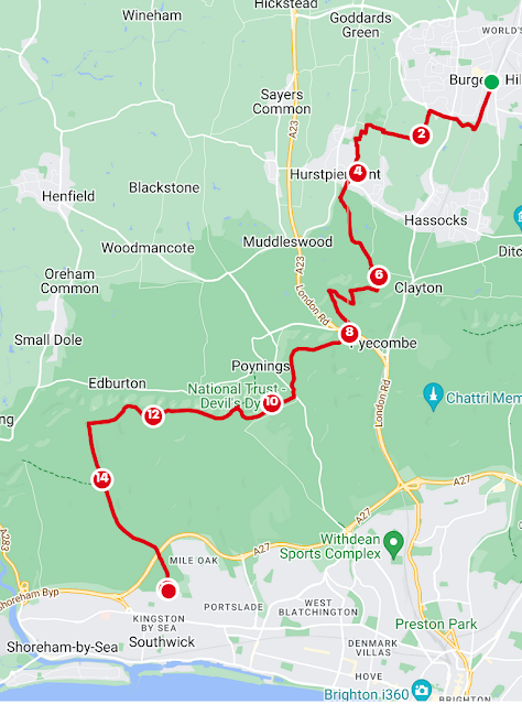
From Burgess Hill Station or London Road bus stop, make your way round the Green Circle and south to Hammond's Mill Farm. Continue south and take the next west to Hurst College. Go over the road and on and just opposite Pitfield Barn Café, go south. Follow the trail until you reach the tarmac then go south on the path that takes you to the east of the houses and east into Hurst Meadows. Go where you will, here, but exit through Trinity Court into Brown Twins Road. Take the first left footpath past the Health Centre and exit onto Hurst High Street. Turn right and then take Pit Lane south past the Recreation Ground. You'll go south and cross a stream called Danny Lake and join a road going east. Joining the footpath again, I found myself enclosed by brambles on a largely watery route all the way to Danny House. With partial relief, I emerged into a splashy field, through what will be, in time, a majestic avenue of oaks that frame Wolstonbury Hill beyond.Danny House will guide you past the alpacas and onto New Way Lane, where you go south then east. There are a few options up the hill but I chose the long and slow route. Head up the drive of Warenne Barn and follow the sign for Woody Bay (52 miles) briefly before veering back south and take the second footpath up Wolstonbury Hill. If anyone knows something about the Woody Bay thing, I'd love to know.
At the trig point, head south then turn right on the track. There's a confusing spidery junction with an additional track crossing the lot but, essentially, take the bridleway southeast between the hedges and ignore the metal gate that leads past the chalkpit. All the way to Pyecombe Manor and over my nemesis (A23). There's another refreshment opportunity to ignore at Wayfield Park Farm Café and shop.
I now endured the worst muddy field ascent to Newtimber Hill. The signposted track by the hedge, behind a partially destroyed fence, is a cow route just above Cow Down. The bullocks, the field contained, eyed me nervously as I sploshed the rivery mud and pat fluid and snagged myself on bramble, hawthorn and nettle. I was in no mood for skipping and dashing. If you have the opportunity, walk in the field. Take the path that heads up to a National Trust sign which tells you you are on Newtimber Hill. You can ignore the official rights of way and follow the track marked on the OS map that takes you close to the peak and left of the dewpond. A blessed relief. You'll reach two proud oaks and I took the path to the left of the smaller hill, descending steeply towards Saddlescombe.
Sorry folks but you'll have to ignore the cake and coffee offerings at the café but feel free to top up your water at the South Downs tap, look in the Information Barn, especially if it's raining and follow the signs for the donkey wheel. Yes, donkey wheel.
I was a bit hungry all the way back at Pitfield Barn and as I crossed Saddlescombe Road, I headed up Summer Down. I hadn't intended to go this way. In truth, use your eyes. This is National Trust managed again so there are numerous paths. What has been viewed already, as you descended Newtimber, is Devil's Dyke itself. By going the way I did, I followed the eastern ridge of the impressive ditch all the way round and crossed it at the end to get to the Devil's Dyke pub. You could, of course ascend the western side of the ditch or take the ditch itself. I like to think of the Victorians taking the train here.
There was now a hiatus for a coke and a fish finger sandwich. Much refreshed I enjoyed the very different view westward. In the Summer, the paragliders are out but today the southwesterly breeze blasted my face, occasionally with a spritzer of drizzle and the sky, blue at times, darkened at others, rewarded my climb with rainbows. Take the westerly route onto the South Downs Way. Just because I could and rarely have, I continued all the way to Truleigh Hill. Not quite to the YHA but south past Freshcombe and Summerdeane Farm. Don't feed the pony. Don't forget, you'll bag Thundersbarrow and Southwick Hill which tops the tunnel of the A27 as you steadily descend. I fair lost my mind down this path. I only regained consciousness when Shoreham Power Station and the i360 swung into view. Exit at the bus stop. I, (eventually). took the 46 bus to Hove and then the train back.


Comments
Post a Comment