Losing Battle
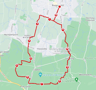
The idea of this walk was to take the low road, nestled between old farmsteads and sheepy pasture and loosely follow the route of an ancient Roman one. This would be balanced with a return via the chalky, afternoon sunlit elevation of the South Downs Way and Ditchling Beacon.
Things were curtailed by home commitments, footpath diversions, and train faults. As it turns out, I still managed a 16 miler and so a final leg on top of the hills was maybe a bit too ambitious. I had several mild disappointments punctuated by some brief joy. The idea is still good and if I can improve the first bit and actually have time for a lunch in Lewes, all will be on for a future go.
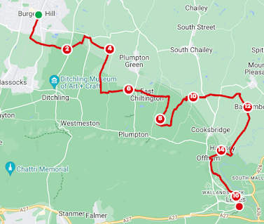
The walk in progress: From the London Road bus stop or Burgess Hill Station, head over Nightingale meadows/south by the railway to the train-waving railway bridge. Cross Batchelor's Farm Nature Reserve to the water tower and out its eastern edge. Cross Ockley Lane and join Wellhouse Lane going east to towards Ditchling Common. Go northeast after the B2112 and if you didn't get to wave at trains, try again as you cross the Lewes line. I then followed the Sussex Border Path by the railway line and houses and crossed Spatham Lane to enter Blackbrook Wood. This is often very muddy and the relative heat of the woods had kept the mud quite pliable, shall we say. These woods are lovely for bird life and bluebells but today they felt almost silent.
As you exit the trees and reach a crossroads, go south towards the railway tunnel. On this route, you will pass the Artelium, another vineyard. After the railway you'll go over the Bevern, a chalk stream via a footbridge at the truly sweet Meadowsweet Cottage. I disturbed a deer soon after.
Now south, until you are level with Streat. The Downs was still cloaked in cloud. You'll be just south of what was once the Roman road, dubbed in modern times the Greensand Way. This is not to be confused with the long distance walk of the same name. At Ashurst and Plumpton Racecourse, you'll be on the actual route. Suzy's Streat Food was not quite ready for me even if the dogs were. I was sad not to take a look around. There are some pretty old buildings here on this quiet lane, from the 16th Century on. To the south, you'll see the Victoria plantation, planted for her golden jubilee and the Plumpton Cross, significant for the Battle of Lewes. At East Chiltington and Chapel Farm, The Jolly Sportsman is just up the road but I pressed on, over Novington Lane and then south on the bridleway to Warningore Farm. Bridleways are, by nature, often a little chewed up. This was no different but, inspired by the interpretation board (I love an interpretation board) I diverted this way to check out Warningore Wood, where Simon De Montfort hid his troops before defeating Henry III. I forewent the hardship of slipping about and was beginning to build some historical atmosphere with the sounds of distant gunfire when a hare almost ran into me. What a beautiful creature! Turning the corner, I encountered the source of the noise and a reason for the hare's retreat as I bumped into a shooting party and their beaters. Downhearted, entering Warningore Wood and heading north on the chalky track, I found I was not transported back to the 1264.
Cross the railway again and go east then north. Still no waves. East again and over Allington Lane, the A275, Deadmantree Hill and on to Curds Farm. North then east, (another deer), south on the road and southeast towards Barcombe. The Church of St Mary the Virgin brought a glimmer of sunshine and some pretty cool memorial stones on a sizeable building. There are good views over to Lewes. How I wished I'd made more progress. Southeast and you'll be on the GMT trail or the Sussex Ouse Valley Way. These two will fight it out on every fingerpost from now until Hamsey.
Here things fell apart because they happen to be working on the river from here to Landport. The footpath was closed. I had to retreat up Ivor's Lane and along to The Drove Southeast Water tried to cheer me up with Offham Marshes but it was too little, too close. The footpath will take you by the woods and Landport Road round to Pells Pools and from here I went straight to the station to get back for the washing and to make tea.


Comments
Post a Comment