Brooking and Wading
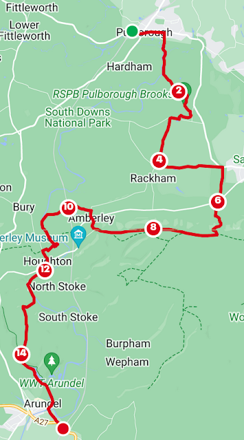
Getting to Pulborough from Burgess Hill is not too bad but you don't want to hang around because time on the train is time not on the trail. A good route is north to Three Bridges and then southwest to Pulborough. You can push on at the end of the walk to Littlehampton for ice cream on the beach if you have time.
From Pulborough, head out the front of the station and east along the A283 or Lower Street. The RSPB direct you south along Barn House Lane and out onto the flood plain to meet the Arun. You'll be directed along the gorsey bank and south to Pulborough Brooks, where you have other options than the public footpaths. Bumblebees were taking advantage of the warmth and the catkins. The footpath will take you to cute little Wiggonholt Church where you can head south to the visitor centre. There is a cafe here.
Press on through the sandy, piney Wiggonholt Common. I did a quick circuit and exited onto Greatham Lane. I went west until I met with the junction with Rackham Street. There are deer fences surrounding these woods but I was suspicious there may have been a through road parallel and to the east. Go east onto the drive at Parham and the West Sussex Literary Trail. You'll pass a lake and the house itself. There is no through road. Continue east through the deer park and out towards Cootham.
Go south on Clay Lane, west at the junction and south onto the footpath at Paygate. You'll ascend steeply up Springhead Hill. Go west at the top on the South Downs Way towards Rackham Hill. I saw the trig point in the mist. On a good day, you'll have views over the watery landscape. You are fenced in until you descend Amberley mount and Highdown on Wey South Path on Mill Lane. Crossing New Barn Road, you enter the town. I stopped at the Amberley Village Tea Room for a large mug of coffee. Continue on School Road to Church Street, heading for the church and the back of Amberley Castle, at the end.
There was a sign advising that the footpath was closed due to a wall collapse but that was being dealt with. What was more challenging was the calf deep water before reaching the river again. A lady had warned me that it was 'very wet'. A little bit of an understatement. After completely submerging my feet, somehow the mud didn't seem so oppressive. Cross the railway carefully and continue to the Arun.
Head south and cross the metal brdge to join the South Downs Way again to head west. Go south when you meet Houghton Lane. and then south on South Lane to, once again, meet the Arun and the Monarch's Way. It was on this stretch that I saw a seal.
Enter Arundel Park and leave the river. You'll steadily climb to be able to enjoy impressive views of the route you have taken. Decending steeply, you can leave the Monarch's Way and join the path beside Swanbourne Lake before meeting Mill Lane.
Great views of Arundel Castle before you pass the Museum and take Queen Street south. Over the roundabout, take the quick path under the road to the station where you can make your return journey.

Comments
Post a Comment