Forest School
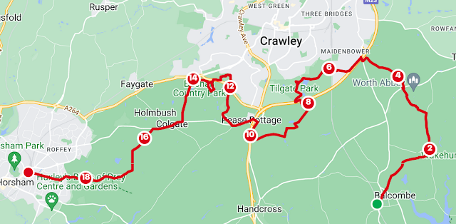
This twenty mile walk was done on a glorious Spring day of sunshine. From East to West you get to straddle the M and A23 on the south side of Crawley. That sounds enticing, doesn't it? Burgess Hill has its own derogatory nickname but then so does the town known for its 'transport links'. The blessing is that the walk is almost entirely within woods of differing characters and there are a few places to explore a bit more on route, if you so wish.
I felt a bit irrationally guilty for turning down last Friday to get my chores done and avoid the rain. This walk, after a dry day, was a long, sunny, vindicating pleasure. There are a few roads and long broad forest drives but don't be deterred because I saw very few vehicles and people until I hit the Parks. At the Parks, there are facilities and potential lunches and exits. And there's Pease Pottage, a place more known for its road services.
Launching from Balcombe station, a short hop north up the line from Burgess Hill. Exit the station and turn left, cross the road to head up Bramble Hill, turn left after Haywards Heath Road and pass the convenience store and The Half Moon. At the end of the road, turn right, enter the field on your left and keep left. Having learnt that the edge of the field is very wet in places, I looped wide before entering Walk Wood. I avoided some but not all mud. I disturbed a heron near the board walk and beyond, the track was surrounded by birds.
From here, Boundary Road is solid under foot all the way to Paddockhurst Lane, where you turn left. This road was quiet, save for the thrushes and firecrests. Paddockhurst Lane turns into Back Lane. I saw a bird watcher with the most enormous camera lens. I didn't greet him in case I scared something away. As you exit the trees, you'll see Worth Abbey beyond the field. Take the signposted path to the left, on the south side of Downside Wood. You'll get further views of the school as you pass, cross the field and exit onto Paddockhurst Road. Turn right and then left onto Standinghall Lane. Bear left at the fork to enter Worthlodge Forest. Marsh tits in a slight clearing.
Exiting onto the roundabout, go anticlockwise, cross the slip road and head over the M23 via the bridge. Immediately turn left to follow the road west. The birds were shouting above the noise of the traffic. Continue on this waymarked path as it heads away from the road and through the houses. You'll cross the railway and enter Tilgate Park. When the footpath meets the bridleway go southwest. You are permitted to take the track straight on and continue west through this less than sterile golf course. Follow the yellow warning signs, rather than the footpath and you'll be in line with the northern edge of Tilgate Lake. The Lakeside Cafe provided a timely refreshment.
There are many routes and attractions in Tilgate Park to divert you for the day. I took the route past the walled garden, through the Peace Garden, The Pinetum and back over the M23 into Tilgate Forest. This part is a bit mountain-bikey but I headed west then southwest to the southwest corner. If you pass New Pond and the fence on the right, the track heads back east. You'll see a small path that heads up the bank at the turn, towards Parish Lane. You exit through an old metal gate.
At this point you can head west all the way to the roundabout. For completeness, I went west and south at New Buildings Farm and followed the path through Bensonshill Wood. It's a case of redundant footpaths on either side of the A23 and meant that I then headed north past Clip n' Climb to the same roundabout. The one feature of this path, apart from a salvage shop and Clip n' Climb, is a bus stop.
Crossing over the A23, you'll pass Pease Pottage Services but then, on the other side, you find Pease Pottage and the Black Swan. This was shut for some refitting and will be opening in a week. Follow the Horsham Road west until you meet the crossroads with Grouse Road and head north to Cottesmore School. You'll pass a radar station, a water tower and the Hogwartian independent boarding school as you go north and eventually take the subway under the A264.
Back on the edge of Crawley, take either path to enter Broadwood Rise. Go past Crawley Mosque, take Jersey Road and turn immediately left up Target Hill Nature Reserve. At the top, pass the pond and then descend and go west.
A sign announces Buchan Country Park. You can stop at the visitors centre but ultimately cross back over the A264 and head west. Like Tilgate, Buchan is extensive. I observed the waterfall then headed between Douster Pond and Island Pond before taking a path just parallel with the A264 heading west. Take the signposted permissive path and head to the northern end of the bridleway going south towards Colgate.
At Forest Road, cross and go right towards The Dragon pub. I was sorely tempted to stop but pressed on. After the pub, continue over the crossroads until you meet a bridleway going south into St Leonard's Forest. If you're a trig bagger there's one just north of the road at Beacon Hill and, incidently, also back at Tilgate. I switched off a bit here, with the long path veering more to the south and being punctuated by dogs.
Just after and parallel to a broad western forest drive, you'll join the High Weald Landscape Trail which will you take you all the way back into Horsham. Ignore the boarded footpath between Dry and Stew Pond and continue to follow the green arrows west to meet Hampers Lane. At the junction, take Depot Road and then Station Road to the Station.

Comments
Post a Comment