Indecision Clouds
Much sighing happened and by Sheffield Park, I threw in the towel. The wind had picked up and my mood was low, It didn't get any better from this point. Do this walk in nice weather and when it is dry and avoid a long road walk as described by getting a bus from the Park itself. Take time to enjoy the streams, ancient farmsteads and mixed woodland. A lazy Summer's day would be ideal.
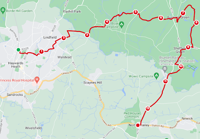
From Haywards Heath Station, a couple of stops north of Burgess Hill, head for the roundabout and go south. Take the footpath east through Clair Park by Clair Hall. Continue on to the B112 and turn left then right at the roundabout onto Oathall Avenue. I passed the college with the tide of solemn children washing in from both directions. Oathall Avenue becomes Washington Road after a daffodil-planted roundabout you can walk through. Take Penn crescent on the left and enter Scrase Valley Nature Reserve. You can follow the Scrase stream, a tributary of the Ouse, through to Croxton Lane and then take the footpath opposite as it crosses back over Meadow Drive.
You'll exit onto Lindfield Common where an abundance of runners converged at the car park. On the Eastern side, take Eastern Road to a second nature reserve. Eastern Road was made a reserve once the sewage works turned tip was made redundant in 1975. I took the woodchipped path east, still following the Scrase. Sadly the woodchip converted to a muddy track which met the concrete path of the Sussex Ouse Valley Way. Heading north you join the Sussex Diamond Way, which will be your guide for the foreseeable.
So far, we've done two pleasant nature reserves which can be explored at your leisure. I had become slightly muddy already. Still positive.
Head east on the Sussex Diamond Way, away from the scary barn at Hangmans Acre Farm and past Lindfield Golf Club. The field was muddy and at this point I hooked my foot through a bramble and threw myself face down in it. Largely saving myself with my hands, I continued only slightly seething at this boring and irritating field.
Crossing the Ouse at East East Mascalls Lane, go north. You'll pass the restored 16th Century Farm and leave the road on Montes Hill, on the right hand side. The sun tried to shine and the fairies pushed primoses in my direction but the sloppy path was winning a little.
You'll rejoin the Monteswood Lane and then take the footpath off to the left opposite Cockhaise Farm. The path climbs a pleasant little bank by some lakes and you can see the Bluebell railtrack to the east as you cross the field. Here I heard some marauding linnets in the trees. No trains running today.
Cross the line and some horse paddocks before meeting Treemans Lane. It was here that I hesitated, trying to make a decision about my onward route. So many potential paths lay in front and so many muddy ones behind. I reckoned I could work my way around Freshfield Brickworks and still make a decision after. Do as I did and follow the path south around the drowned quarry. As you carry on, you can see more excavation to the south before meeting the Lane.
Go northeast up the road and take the next path on the right which will take you past Kidborough Farm and Butcher's Barn in the next field. The next path is the one that broke me. I car's width of mud of unknown depth. I could have wept when I reached the bench on the hill at Heaven Farm. Descend to the buildings. You'll pass Latchetts Ice cream or maybe you won't. I almost had one to cheer myself up but as I had to hail a member of staff to man the out-of-season counter to get one, I decided against it. Cross the road and head south on Tanyard Lane.
On the left, take the drive at Portmansford and past the farmyard through a gate between the houses. You'll reach some angling lakes you go between. At the time of writing, the path immediately after on the right was closed because of a dangerous footbridge. I tried to imagine a footbridge more dangerous than the savage mud I'd navigated. Nevertheless, I drove on north to Colin Godmans Farm, going east towards the pond. A single Canadian goose plied the water.
Enter Sheffield Forest and the pine and go south to meet another path going south. There are numerous routes through but I was able to detect the footpaths by the footfall in the mud. Southward will take you past Sheffield Mill Pond back on the Sussex Diamond Way and through North Hall Farm. I had hoped to make entry into Sheffield Park from Eastland Wood but I am doubtful this is allowed.
You can go west on North Hall Lane and then South on the A275. This is not ideal walking but you're well signposted to The National Trust property. There are many available walks in the Gardens and the Parkland. I ate at the Coach House Cafe which is outside the reception area and had little energy for further exploration.
There is a bus stop at the property but Google told me I could catch a quicker route on the main road. A track south in the parkland takes you off road to these stops and Sheffield Park Station. The steam trains here won't get you home on the Bluebell railway. I missed the bus stops as I ran out of signal and data and wasn't sure where they were. In the end, I took a depressing and dodgy walk all the way to the Kings Head in North Chailey, the yellow 150 bus passing me on the way. I did, however, get home in good time via Haywards Heath. Another day.

Comments
Post a Comment