Knights, Dragons and Fire
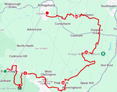
Pulborough can be made by train via Three Bridges but it does feel on the pricey side at rush hour. Return from Billingshurst is on the same line.
Having ventured out from Pulborough via Old Place, a few times, I took a route from the station that led me past New Place and gave me more of a view of the village's old interior. New Place is actually Pulborough's oldest building from 1252 with some bits being Tudor. Conversely, Old Place is a junior from the 15th century. From the station, walk through to the footpath on the other side of the bike rack and parallel the railtrack north. At the bridge, go east on Church Place. St Mary's was shut but you can walk round the sizeable graveyard on the hill. As you cross to the bridleway, you a crossing what would have been Stane Street or the A29, as it is known today.
From beyond the Chequers Hotel, views are yours to the south and the Downs. Some interpretation is provided via the WildArt Trail which you have so far been following. Leave the bridleway north and head towards the Recreation Ground. Continue over the grass and you might see the signage for the pocket park, the wooded area on the edge. Walk via the footpath through to New Place Road and over it. You will join the bridleway going east. You can't actually see much of the old building so go south on the footpath at the end. The grassy area on you right represents what remains of a moated manor house. I neglected to even look at it. When Moat Lane meets Rectory Lane, continue to the junction with Lower Street. Just a little west is Rivermead and a footpath on the right will take you out onto the floodplain.
Things were very much drier here than anyone might want but the river looked serene amongst the gorse. The river Stor feeds into the river Arun and you cross the footbridge to follow its bank. Leave it when indicated and cross to the Pulborough Brooks Nature Reserve. The public footpath continues to Wigginholt and the church. Temptation had me take the path into the reserve instead. As a RSPB member, entry is free and is open from to dawn to dusk. A cafe, shop and visitor centre to take the entry fee are open from 10. Being much too early, I guess a donation is in order because I ventured east and sat in Nettley's Hide for a little while. Even before this, I heard the lapwings calling from the much depleted water.
Going south and rejoining the footpath, bear left and continue over the stile and beyond the church. Continue going left to loop back north to Lickfold. You are on the east side of the Pulborough Brooks. Roman remains punctuate the landscape. The Greensand Way that runs through to beyond Hassocks, begins at Hardham in the west, Pulborough being much more important as a place before roads led to London. A villa was just east of here and a causeway across the Brooks goes to the site. Worthing Museum is home to the Pulborough hoard, 1559 copper alloy coins issued between 251 and 273 AD, found in a patera in the mud. Go north to cross back over the Stor and meet the road.
Go right on Mare Hill Road and past The White Horse. Cross and take Batts Lane. Stay south of Nutbourne and on in an easterly direction to Stream Lane. At the first opportunity, turn right on the footpath through Mill Farm. Make your way through the cow field until you can go east. This involved some graceful rolling under electric fences to avoid cows but wasn't too much bother. East takes you on to the West Chiltington Recreation Ground. Cross to the northeast corner and go north on Mill Road. The footpath on the right will take you past the foot of Meeten's Mill, a converted smock windmill that originally stood in Monkmead. There was a strong smell of dog poo rising in the heat. Go right, left and right again to traverse Haglands Copse and meet Haglands Lane. The roady continuation is a bridleway through to Smock Alley. Go south over the bridge and continue on the bridleway through Highbar Copse to Highbar Lane.
At the housing estate next to Storrington Road, the heat was searing and there was little shelter but I had a location to tick off. William Penn, the Quaker and founder of Pennsylvania preached from a rock. The stone that marked the spot, commemorates this and stands next to the pond on Abingworth Crescent. I don't know whether this was the original position. I didn't spend long to ponder because I was too exposed to the sun. Instead, I cut through the back of Penn Stone Way to join a footpath. It seems this isn't really allowed and, as an alternative, a newly designated bridleway leads from Pavillion Close, on Abingworth Crescent, for the same purpose. Either way, join the footpath going east as it steers north to Thakeham Place Farm. At the junction, take the bridleway into Thakeham itself and towards the church. On The Street is The White Lion Inn and I had a welcome lunch. It was very timely and peaceful.
From The Street, take the steps north into The Glebe. This is land that would have been used to support the local clergy. The field is now a meadow managed for wildlife. There is a trig on the road to Bramblefield but take the footpath that heads away and downhill to the east. The view is a bit of a nice surprise. I took my eye of the ball here and found myself on the wrong side of a tyre swing. Head to Crays Farm. I ended up on a permissive path to reach the lane. Go over Billinghurst Road and through Bowford Farm on the bridleway. At Hooklands Lane, turn right and find the bridleway that carries on north. Now cut through to the footpath on the right and through Benton's Place Farm.
It is here you find yourself on the Knepp Estate and you can use their footpaths through this area of rewilding. I kept losing myself and taking the wrong route. The heat was playing no small part in my error and discomfort. I paused a while under a beautiful mature oak. This was in the same field where the storks are nesting in their oversized homes. While there is no evidence they ever bred in numbers in the UK, captive storks have been introduced and their offspring have returned. They are still a sight to behold. But then I've been reading about cranes, their history and recovery and find this far more compelling. Behold the golden glow of abundant ragwort, a patchwork of fields, wood and muddy hollows.
Make you way, probably in a more efficient manner, over Countryman Lane and to King's Mill. The bridge was out before reaching here and there is a diversion to School Lane. At Shipley, you can visit the Knights Templar church of St Mary's. There is a story about a rediscovered stolen reliquary, now at Horsham Museum. I was charmed and my thoughts went a bit Da Vinci Code for a while. The other things to note is that Shipley or 'sheep meadow' was probably more of a mooring on the more navigable Adur. A lump of iron stone is in the porch which is thought to have been a bollard for this purpose. The final thing to note is that my thirst called upon me to ask the reverend, who walked into the church before me, if there was a tap. He kindly obliged and I hydrated in the cool of the building.
Out on to the Causeway and then Red Lane, go north. Leave the road and continue on the footpath through Greenstreet Furzefield. Just south of Dragon's Green, take the footpath that takes you to the edge of the Coolham Road. Cross with care and go directly north through Renche's Wood. I paused at a gate indicating you are entering the Dragon's Estate. This is land owned by another branch of the Burrell family. A fox also paused to look back at me in the haze, before darting into the trees. Join the bridleway continuation and turn left when level with Goffsland Farm. At the edge of the trees, switch north again. So far, I was partially shaded from the afternoon sun but soon I was to be hassled by unfortunate footpath placement. I had to steel myself for the final push towards my goal.
At the end of the wood, go left onto the bridleway and what is the Sussex Diamond Way. Head to the junction on Oldhouse Lane but then cut some distance by following Lackenhurst Lane west. It is a sleepy road. A bit south of the junction is Emms Lane and you're back on the Diamond Way again. For reasons of simplicity, I stuck to it, all the way back to Billingshurst. Even when I tried to knock a corner off before the Literary Trail, I found myself walking under a giant pylon on the Diamond Way. Just go with it, as it joins West Chiltington Lane. Eventually, the path joins Fewhurst and crosses the Coneyhurst Road. On the other side, pass the traveller encampment and walk the edge of Rosier Wood. The path exits on to the Lower Station Road. Go north to get a train home.
A Tesco meal deal had to suffice for tea. I was still happy. The mundanity was a comfort when the apocalyptic heat seemed out to get me. It was a relief to regulate my feelings when I frequently swing to thoughts that we are experiencing the climactic end days.

Comments
Post a Comment