Hills are alive
We had an unbearable amount of rain yesterday and walk one of 2024, despite the promise 'of little or no break in the cloud', needed to lift me above the standing water. It was necessary to forego the hard-going slop and exchange it for a way of easy navigation and big skies. The walk was a reprise and a contrasting high road to this other Lewes route, that subjected me to setbacks and muddy aggravation. I was surprised by how much progress I made, even with extra mooching about. This goes to show that a well-watered path might be good for the calf muscles but not so great for morale.
However, Burgess Hill and Hassocks did not leave me alone without a fight. If you want to walk from this Sussex town, you'll find there's no escaping some hardship after a downpour. Even with the relative lowlands making their best efforts to ruin my trousers, the surprise afternoon sun and wide vistas of the South Downs Way brought me relief. Just a shame the big camera is still at the camera doctors.
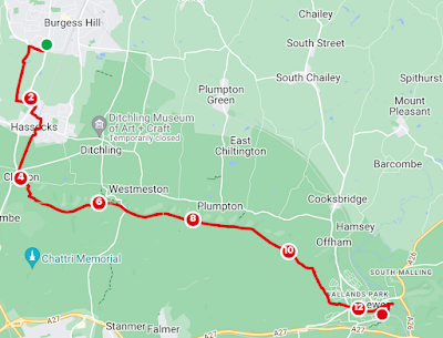
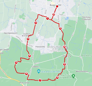
From the London Road bus stop, take the Green Circle footpath just south of the roundabout going west. At the meadow, head south past Hammonds Farm. Over the Mill Race, go east then continue south. I veered onto the old golf course along here because the path was, at points, a river bed of overflowing and foaming ditches. The former golf course is adjacent a fairly new housing estate and throughly used by dog walkers. East, opposite Belmont Lane, will eventually take you through the houses and onto London Road.
Heading south, you can take Shepherds Walk, Priory Road and Little Copse Road to take you through the horseshoe-shaped tunnel under the railway. South on Woodsland Road and then west over the roundabout onto Keymer Road. At the first opportunity, leave the comfortable road surface and join the footpath going south. There are two quite close to eachother. The second follows the railway line closely but the first will join it soon after some houses. I opted for the first as there were some conveniently place stepping stones. It was still awful. Once at the railway line, you'll travel thoughtlessly past Butcher's, Lag Wood and Pembury House Garden, all of which will have their bluebells in April and emerge onto Brighton Road. You'll glimpse the turrets of the Clayton tunnel before you cross New Road and enter Clayton Recreation Ground. Cross and exit the car park and go over Underhill Lane. Take the path going up the hill to the windmills. You can visit Jill, who is white and has her sails, on some Sundays but Jack is a private residence and looks a bit sad and naked. The footpath goes in front of these but I crossed the car park to get a closer look and joined Mill Lane and the South Downs Way.
You'll now follow the ridge to Ditchling Beacon. The trig point lies, unannounced, a little to the south of the path before the roundabout. On the way, the hill is dotted with tumuli, a dew pond, sheep and cows. Views are available in all directions. You might spot Oldland Windmill, Brighton and the sea. On Summer days, an ice-cream van will sell expensive Mr Whippys from the car park. The sun timed itself right, in order to shine at my arrival.
Cross Ditchling Bostall and carry on. We are the other side of the Queen Victoria's Golden Jubilee Plantation and the Plumpton Cross but also don't miss Blackcap, a pretty wooded hill replanted in 1953. After Mount Harry, a small parallel diversion will take you to Landport Bottom and the site of the Battle of Lewes, on the Greenwich Meridian Trail. Cliffe Hill, Lewes Castle and the floodplain of the Ouse are all visible. Either path will have you descend to Lewes prison with its flint walls and enter historic Lewes.
I went to the Riverside Café. Other eateries and pubs are available but Bill's is always super busy. If I had a longer day, I might have continued my walk but, at 13 miles, I decided I'd done enough and caught the train back to Wivelsfield Station and walked back into town.


Comments
Post a Comment