Well Done Us For Getting Out
Another trip out of town, took me further along the South Downs Way. The forecast was uniformly grey, which is fine and I'm glad to report that the mud did not set in until my return journey past Wilmington. On the train, I had an hour to remember that I was still not feeling a hundred percent after suffering a sniffly cold. On the ascent, it was an easy decision to postpone a longer jaunt until sunnier times. I have memories of coming down from the hill to Jevington through dry meadow and butterflies. Not today.
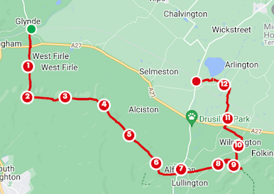
Taking the train to Brighton and then out to Glynde, gives access to a direct southerly route up to the South Downs Way. With a slight wiggle, you'll go down Lacys Hill, cross the A27 and continue on Littledene Lane. A lonesome road on this grey morning. What was apparent, was that the cloud was so very low as to find myself essentially walking within it, as I ascended. I raised my hood because of the level of mizzle. Further along, the wind breathed through some pines and rattled the telegraph wires in a rythmic dirge. The ground dipped away to the right but I was not able to clearly see the hill I was climbing. It made me feel quite isolated but not in an entirely unpleasant way.
When you reach the top, you'll be at the junction of some paths and the South Downs Way. Views are probably impressive but I was having none of it. I had the immediate excuse to do this route again, imagining the heat of the sun on my face and the serenade of the skylark. Right now, the wind began its blasting of my right cheek and visibility was down to about a hundred paces. The Radio station marched into view on Beddingham Hill and the peaceful sheep sat and fed. A flock of what I think were starlings were wheeling about in a rather surreal way, amongst the white noise. Onwards past the masts, my journey remained featureless, aside for the fence on the right and a British Telecom manhole cover. It was like walking on the moon. Just after and through the car park, I met a couple of weather worn runners and a lady walking in a similar capacity to myself. We both expressed a little wonder at the misty conditions and the shapes that appear out of nowhere. Views should be abound but to have none was an experience in itself. It was nice to share. Still, 'Well done us for getting out.'
You'll reach Firle Beacon, a marilyn at 217 metres. The trig point coughed and raised its hand to the left of the trail. A little further on, a chalk boulder is inscribed with the word 'foundle' an effort in the name of art by Jo Sweeting. Some of the stone involved was inscribed using a flint, a practice of some synergy as you'll begin to notice the presence of neolithic workings and burial mounds on this high point. The mounds were brought into sharper focus as little else was discernible for me. Later you'll wonder how anything can be cultivated in the flinty fields.
After a second car park and Bostal Hill, you'll begin to descend towards Alfriston. You traverse a cross dyke, an ancient man made feature of uncertain purpose. First views of the church suggest civilisation. You emerge at a busy walking junction. I was, at last, below the cloud and the sun was now more than a pale disc to the south. If you turn right a very short distance, then left, you'll read the interpretation of Long Burgh Barrow. Continue South on the South Downs way to enter Alfriston.
From Star Lane you reach the High Street. Once here, you have a choice of eating options. I stopped at The Badgers Tea House because it was not empty and I felt less awkward with my wet bobble hat. There are other diversions in Alfriston, including the National Trust Clergy House, which was not open when I walked.
My original intention, as has been said, was to ascend once again but considering the outlook, I shortened my route and headed off towards The Long Man of Wilmington.
Back to the market cross, take a left down to the Cuckmere and River Lane. Go over the White Bridge or Plonk Bridge. You are still on the South Downs Way until you cross the Lullington Road at the Great Meadow Barn, otherwise known as Plonk Barn (why so shy?). Go right then left on the footpath marked the Cuckmere Pilgrim Path that rejoins the South Downs Way shortly after. Rather sad that I didn't visit Lullington Church, one of the smallest churches in England and visible on the right. Seagulls and crows pecked at the stalks in these fields and, looking around, I was validated in my decision not to extend my walk, considering the cloud cover. Frankly, I was also feeling a bit peaky.
After crossing The Street, you'll climb past a reservoir. It was probably my tiredness and lack of visual cues but the mess of path options here saw me choose to loop the South Downs Way over Windover Hill. There might be some nice viewing reasons to do this but the sheep I saw below me were like tic tacs and little else. You can walk a more direct route. When you reach the gate, don't go through it but bear left and head back down along the fence and left again. If you go through, there are some more paths marked as tracks on the OS map that ascend and descend Wilmington Hill. From the fence, you are actually just above The Man himself - probably a bit more obvious when visibility is good.
At the crossroads, go east and you'll begin to see The Long Man as intended. Go north directly in front of the image and keep turning back to see him as you head towards The Street. At the road go right past the car park and continue to Wilmington Church, worth a visit for the 1600 year old yew tree.
At the telephone box, turn left and you'll be on the Wealdway marked with WW on the posts. At Milton Street turn right. Go over the A27 and continue to follow this long distance trail over the Endlewick level crossing and left to meet the Cuckmere again. The Pilgrim path and Wealdway are fighting out to the road. Go over the bridge and take the footpath or road following the Cuckmere west and cross the road to the field and nature reserve on the edge of Arlington Reservoir. You could skirt the whole thing via The Osprey Trail, once you reach the road but I was tired.
Go left briefly then right over the last little round hill of ponies as you head towards Berwick. Just to the left is Berwick Station when you exit onto Station Road.
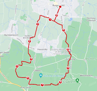
Return to Burgess Hill was actually quicker via a detour to Polegate then back to Wivelsfield Station and crossing the tracks once again for Burgess Hill. Yet another walk in the bag for another day.


Comments
Post a Comment