A Bridge Too Far?
This is the third in a series of walks that I've made in this area. It it a bit too long at 20 miles. Again I underestimated the amount of time it would take me and I was, as a consequence, very hungry. I have, however, squeezed in quite a bit of interest to make up for a lack of food. There are a bunch of nature reserves, watery landscapes, sandy woods, a Roman villa, castles, ancient roadways, old railways and a cluster of medieval and younger bridges vying for importance.
The fast-moving sky was assisted in allowing in occasional sunshine by a fresh northerly breeze. The walk is largely flat and on the flood plain and so expect mud and water. There is a brief ascent above Bignor for variety.
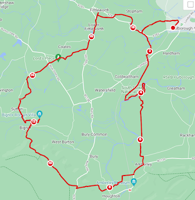
Leaving the station, head to the left of the bike rack and through to the path to the left. You'll follow the track and emerge onto Coombelands Lane before crossing it. Now heading west, the path leaves the road on the left and meets a WWII gun emplacement. There is some information to be found here and a reminder of how war came to this part of the world. Crossing the road on the other side, at Park Farm, leads you to Pulborough Park Plantation. Park Mount or Mound is visible on your right and is a post conquest motte and bailey castle. From the edge of this splendid sandy path in mixed woodland, there are views southwards until you reach Stopham Road (A283).
Over and visible from the newer road, go down to the White Hart and the Stopham Bridge that spans the Arun. The distinctive triangular cutwaters either side are, apparently, for pedestrians but you won't see a lot of traffic. Take this road past the pub front door and continue south on to the Wey South Path. We will return to this point later and I imagine teatime at the pub would have been just perfect but I had to push on.
Over the Arun and the Rother, the route takes you through the pumping station and westwards to join the end of the long dismantled Pulborough to Midhurst railway. Ignore this permissive path and go south instead, over the existing railway to London Road.
Cross the road and a little on the right, take the pleasant wet woody footpath south to Waltham Brooks Nature Reserve that runs near the remains of 13th Century Hardham Priory. The walk takes in a quick circuit of this carefully managed watery reserve. It includes the remains of the Wey-Arun canal where a short cut ran in part through Hardham Hill, now closed off. Lazy brown cows were strewn about. Follow the path within the reserve that takes you on the bank between the old canal and the Arun and back to the Greatham Bridge. This has had a lot of work done to it over time but its roots are back to the medieval again.
Once across, switch to the opposite bank south that takes you past Quell Farm. Well directed, you'll reach Amberley Brooks an area of grazing marsh and ditches. There is only one path which is surfaced in small parts. I'd been nervous about this section after my wading experience on a previous walk in the area. Thinking I'd made it unscathed, I promptly submerged one leg up to my knee. It emerged only slightly muddy due to the wet conditions, so that's a win.
You'll spot the castle and become surrounded by gorgeous thatched homes as you enter Amberley. continuing south on Hog Lane, go left into Church Street. There are eating options here I probably should have taken.
By walking on New Barn Road, it is possible to avoid the wet experience I'd had by reaching the Arun via the other end of Church Street but you may find this a suitable and a less roady option. As it was, I headed onto the South Downs Way as it crosses the railway at the end of Castle Lane. The other side of the castle is visible from the bridge. You could also go straight over the end of New Barn Road to continue on the Wey South Path via High Titten but I thought it a bit of a drag to ascend and come down so soon. So follow the fingerposts, past the sewage works, across the Arun via the footbridge and then over Houghton Road.
The South Downs Way will take you up the hill so you can appreciate the landscape you have been walking thus far and is the only real up on this walk. There is a water point here for refills. A runner lapped me twice during this section and I saw the many people on this popular path. Most of the drama on this hill section is looking back over Amberley and the steep tree-lined descent into Bignor. Even the trig point beyond the A29 was lost somewhere over Westburton Hill. I tried to look for the Roman Villa from here but I'm not sure it is visible. You'll leave the South Downs Way and continue straight on the bridleway as it skirts Egg Bottom Coppice. Bignor Down will take you north out to Jay's Farm.
At the junction, ignore the sign for the villa but continue north so you can join the footpath running east, further along. Here you can enjoy the mosaics stumbled upon by George Tupper and his plough. The place has enormous obvious Roman history but the excavation and museum itself are part of the story and it is a delight that the Tupper family are still running it two centuries later. Check opening hours and take a break here.
I needed lunch as I'd reached here maybe a couple of hours after I intended and so I strode on to Sutton. On the West Sussex Literary Trail, leave the curiously square road sytem at Bignor on the west side and head north. At Sutton is the White Horse Inn but this seemed a bit too classy for someone steeped in marsh and chalk. Disappointment fuelled me north on The Street and right onto School Lane.
At Keyzaston Farm, you'll join stage 8 of the Serpent Trail. This 65 mile route through heathland showcases some extraordinary environments for fauna and flora and I saw a beautiful red fox on the hunt. Onto Lord's Piece and Sutton Common you can wander freely. This is home to the field cricket, once thought to have been extinct. The area is managed by the Barlavington Estate and it is an interesting and wonderful tale of environmental management.
Heading towards the northeast angle of the triangle, rejoin the serpent trail through Coates Common. At Tripp Hill, take the road north. You'll cross the Fittleworth and Clappers Bridges over the Rother and pass the once coaching inn The Swan. This is due to reopen at the time of writing. The place has seen artists, writers and musicians as visitors. I took the road all the way to the Fittleworth Stores where I devoured cake and coffee (too late for lunch). Take the footpath on the north edge of wooded Fittleworth Common and over The Fleet. Go to the right of the pond and follow the path around to the east at Walters Plantation. Back on the road at Stopham, go south past the church and join the A283 east. Beyond the derelict lodge house at Stopham Place, you'll recognise the old Stopham Bridge. You could have a well-earned pint before returning the way you came. How I wish I'd had time for this.

Comments
Post a Comment