Project Local

This walk was conveniently near home and for the benefit of a little volunteer celebration for the Lost Woods Project. The day was spent with workshops, chit-chat and reflecting on the good work the people of the Low Weald have been doing in aid of all things living in ancient woodland.
Even now, there are paths less travelled and Burgess Hill has the rare opportunity of having new footpaths in the near future. While much of the voluntary work has been done to record valuable data on the wild assets that remain, many individuals have been concerned with preserving and improving the woods, their flora and fauna and protecting this from the harms of development. It is the addition of houses on the north side of Hassocks that has seen in the commiseration of a new connection between Batchelors Farm and this new estate. It means that there will be a more direct interior path south. While you can do this already, the surface is being completed and will feature in the future (watch this space). This lady has only lived here for around 15 years and while the town centre has deteriorated steadily, I have had the dubious pleasure of watching the encroachment of houses upon all sides of the ancient byways I tread. For now, I am content to mop up a few more routes for completeness on this balmy Autumn day with a misty start.
The route loops from the station but you could pick your favourite bus stop in town.
The route was very much like this one, which goes to show what an excellent loop it is, The variation keeps to this side of the Wivelsfield Lewes line. On this occasion, I chose the Sussex Border Path to make it to Mac's Farm.
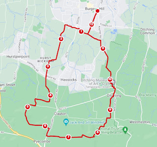
From Burgess Hill Station or the London Road bus stop, head towards Batchelors Farm Nature Reserve and the train-waving bridge, on the south side of town. If coming from the former, on the footpath on the east side of the track, take the first bridleway that heads away from the line in an easterly direction. If coming from London Road, you'll cross the bridge and head north before taking this. Cross Oak Hall Park and continue the Green Circle route to Keymer Road. Head towards the roundabout and take Birchwood Grove Lane. Continue past the school to cross the stream and then the footpath through to The Holt. Cross Kings Way and enter Cold Waltham Lane. Turning left, the end of the lane butts up against the track and you take the footpath on the right, at the back of the houses. You pass the Burner's Close play area on a track called The Woods and this continues to Fragbarrow Lane.
All manner of controversies arise here. You find yourself walking between the new houses South of Folders Lane that saw the mobilisation of an Action Group to try and defend this greenfield site. As well as ripping out ancient hedging, the developers had the go ahead and slowly but surely, more houses, without any additional infrastructure are dumped upon the town and are in construction on each side of this path.
Looking south, we make it to Ridgeview and Fragbarrow Lane. We are right on the boundary of Ditchling and the name of Fragbarrow is derived from the ancient name of the area Frekeburgh. This defined a royal forest chase of King Alfred. He is the King of Kings Way. As the great wood on the hill was broken up and colonised, Ditchling Common became surrounded by farmsteads. Walking the Lane to the main road, you will pass into Ditchling proper and after Fragbarrow House and further north, is Hopkin's Crank. This was once home and commune to Eric Gill, prolific and profligate artist and sexual deviant.
Cross Common Lane and enter Ditchling Common Country Park. The mist hung low over this grassy mound but the sun was sure to cut through. There was a lonely moon-like approach to the railway line. At the railway bridge, Stay on the same side of the tracks and continue now southward, on the Sussex Border Path. You go out the corner of the park and south. Be sure to follow the wiggles indicated, along quite a muddy track behind a poultry farm and garden centre.
The SBP will take a right turn on a more substantial track. Ignore this and continue south and over a footbridge. You are in Mac's Farm where there are many chickens, you can go camping and get something to eat in the Summer.
After the event I looped it back home.
Continue southwest past the hen hospital and then south through the double gate and hens. The hens were very friendly. On the edge of Stoneywish Nature Reserve, turn right and cut through to East Gardens. You could have some lunch at The Green Welly, for example. Otherwise, Cross North End and enter Boddingtons Lane. You can climb Lodge Hill. This prominence lies on the Roman Road. Make you way North to the stile. If you're lucky, you will see some pretty cows before exiting onto the lane going north. You can take the track on the west side of the road for a better view west.
At Oldland Windmill, continue north on the bridleway and eventually you will exit onto Ockley Lane. Walk carefully north and as you enter Burgess Hill, turn left back at Batchelors Farm. The iconic water tower is on your right. Descend the hill on any path and make your way to the railway bridge. Wave at the trains.
Your return depends on your destination but it is west to London Road, north on the east side of the track or north past the pond and Nightingale Meadows, Wingle Tye and Chanctonbury Road. You can't go far wrong here, on your way to town and the station.
Comments
Post a Comment